
|
WARG 2010 Excavation – St. Cross Park
This summer will be our fourth season of excavations in St. Cross Park. In 2007 we carried out a geophysical survey, using resistivity, of the park area. This produced some interesting features. The results of the survey were combined with archival material to guide our digging over the next two years.
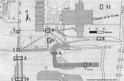
Missing buildings (9 on the map, numbers are Trench Nos.) When Cardinal Beaufort, Bishop of Winchester, redeveloped St. Cross in the 1440s, the quadrangle was closed off by a range of buildings at the south. These were demolished in 1789, and today’s wall and railings were built on the foundation of the wall.
The southern range was shown on maps as identical to the still existing western range. We uncovered a large area of the building and confirmed that the Lockburn, which runs behind the western range was originally a sewer, ran behind the missing buildings.
Garden wall (1, 6, 7) Behind the western range are gardens. Today these end in a wall at the south end of the range. Early drawings show the gardens continuing into the park. It is possible to see the extent of these gardens in the field as the wall foundations show up as lines in the ground. We confirmed that these lines are indeed the wall to the missing garden.
Boundary ditch (5, 10) The western edge of the park is higher than the rest, and there are the remains of a ditch dividing the two areas. We have discovered that this was around 2.5 metres deep, and was not used for drainage. At the northern end, by the path from St. Cross Road, the ditch cut through a filled pit. The pit was created by the Saxon inhabitants of Sparkford, the old name for the village. Since the ditch was dug after the pit was filled in, it is almost certainly a boundary ditch dug when Henry of Blois established the original Hospital in the 1170s.
The Park The Park, between the Hospital and the cricket ground, has intriguing humps and bumps. There have been theories about what these may have been, but these have been more flights of fancy than grounded on evidence. We have combined exciting archival finds by John Crook, the archaeologist of St. Cross Hospital, with physical evidence in the ground to draw up a clear picture of what the humps and bumps represent.
Unknown building (12) Part of our resistivity exploration covered the area to the east of the church. Under the bowling green we found a large building, which a small test excavation showed was an extensive, well-built stone structure. This will, we hope, be the subject of a major excavation, perhaps in 2011.
Water feature? (3, 4) Geophysics showed a roughly rectangular feature in the park. Excavating produced mediaeval rubble mixed with Victorian rubbish, then large lumps of building rubble. An early map showed a rectangular area, surrounded by water and fed from the Lockburn. Our excavations uncovered a deep ditch which originally had water flowing through and later was filled with demolition rubble from the missing south range and mediaeval material removed from the church when it was restored by Butterworth in 1865.
Excavating in 2010 WARG will be on site for the first two weeks in August. The object is to tie up the loose ends before writing a report on the Park. This will include identifying the different phases of the re-direction of the Lockburn, examining the boundary ditch as it reaches the cricket field and learning more about the rectangular “water feature”. |